

The Albuquerque City Council is expected to vote on the redistricting map Monday night. There will be a public comment session on the bill. Council will also have to option to once again defer the redistricting vote.
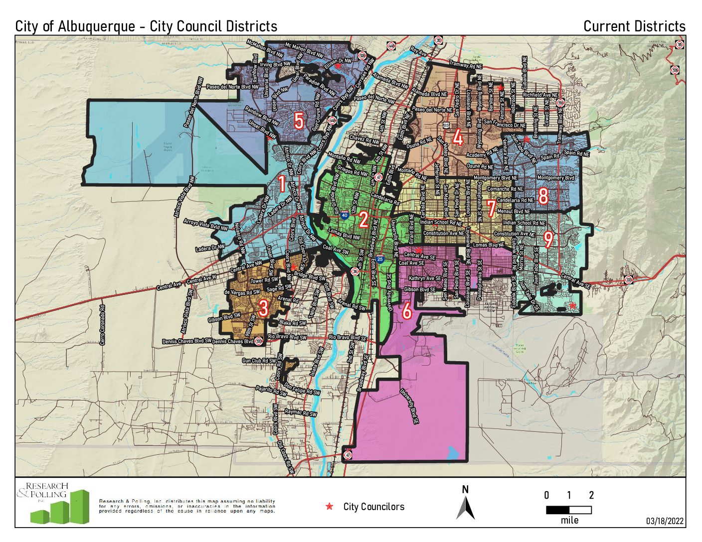
The city charter requires that district lines be redrawn every 10 years. A committee is appointed by the council and is composed of an equal number of representatives from each district, one voting member and one alternate. The council reviews and makes recommendations on redistricting based on information from the federal census. The committee is tasked with redrawing boundaries based on population, nothing rights, compactness and other factors.
An ordinance to establish new districts, O-22-34, sponsored by Councilors Brook Bassan and Klarissa Pena, references Exhibit A and contains Concept Map A, the highest-rated map from the committee. The council has the option to amend or substitute that map with another of the committee’s recommended maps or a new map. It’s objective was, “Minimal change plan to account for population changes and minimize voter confusion.”

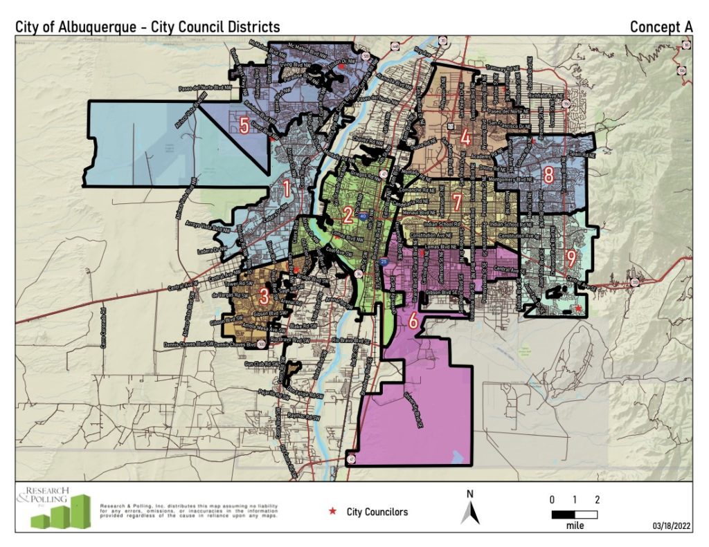
The map has no incumbent pairings, and Districts 3, 4 and 9 remain identical to the current map. However, District 5 lost population and the map moves its boundary with District 1 north to the bluff south of Petroglyph Estates; District 2 crosses the river between Central and I-40 to Coors, taking the West Mesa and Pat Hurley neighborhoods from District 1; District 6 moves west into District 2 from Buena Vista to I-25 between Gibson and Lomas and also takes the University West area from District 2; District 7 moves south into District 2 from I-40 to Lomas between I-25 and Carlisle, not including the University West area; and District 8 moves into District 7 from Montgomery to Comanche between Wyoming and Eubank.
On Sept. 7, Councilor Pat Davis recommended replacing the map with Citizen Map 4, while Councilor Tammy Fiebelkorn proposed an amendment to change it out with Citizen Map 5.
Citizen Map 4, originally known as the Davis/Fiebelkorn map, had an objective of rethinking the orientation of Districts 6 and 7 without adjusting other districts.

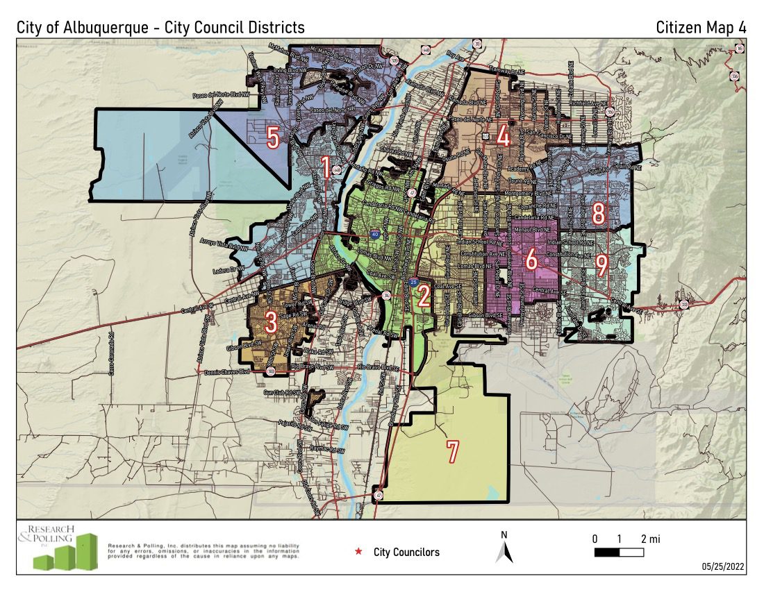
Under this map, incumbents from Districts 6 and 7 will be paired in District 7. Other notes on the map state District 2 takes the two Kirtland Addition precincts; Districts 6 and 7 take on a vertical rather than horizontal orientation; District 6 takes everything south of Menaul between San Mateo and Eubank as well as the neighborhoods between Candelaria and Menaul between Louisiana and Eubank; and District 7 stays south of Montgomery, east of I-25 and mostly west of San Mateo.
Citizen Map 5, originally the Fairness for Our Future plan, had an objective to increase representation for the west side and to create an additional majority Hispanic district. It pairs incumbents from District 6 and 7 paired in district 7, and the incumbent from District 2 is moved to District 6.
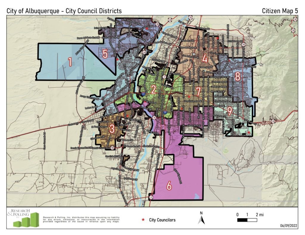
In this map, Districts 2 and 6 criss the river to Unser between Central and I-40 with District 6 taking Barrels; the other districts remain similar to the current map. Additional notes state District 5 is similar to Concept A with District 1 moving a little north into District 5, keeping 5 on the negative side of allowable population deviations; District 2 crosses the river to Unser between Los Volcanes and I-40 and takes the two West Bluff precincts north of I-40 and east of Coors; District 2 stays north of Bell between Second and Buena Vista, keeping the Huning Castle neighborhood but losing the Albuquerque Country Club to District 6; District 2 crosses I-25 to Carlisle into District 7 between I-40 and Montgomery; district 6 crosses the river to Unser between Central and Los Volcanes and also crosses the river south of Central to the ditch; District 6 stays south of Central between Buena Vista and San Mateo and then moves to Lomas between San Mateo and Wyoming; District 9 moves west from Eubank to Wyoming south of Menaul; District 9 stays south of Indian School as District 8 moves south from Menaul to south of Indian School and east from Eubank to Morris; the boundary between districts 4 and 8 changes slightly, with District 8 moving north into District 4 from San Antonio to San Francisco east of Ventura; District 4 moves east into District 8 from Wyoming to Moon between Academy and Spain; District 4 moves south into District 7 form Montgomery to Comanche between Carlisle and San Mateo; District 7 takes University of New Mexico and the north campus area from District 6 while moving south of Lomas to Central between UNM and South Mateo; District 7 curves around District 9 to Indian School between Eubank and Morris.
All maps and their descriptions, as well as full information on the redistricting process can be found here.
Additionally, the full agenda for Monday’s meeting, which starts at 5 p.m., can be found at https://cabq.legistar.com/Calendar.aspx. The public can sign up for public comment here, or written comment can be submitted through the Contact Your Council form.


